Himalayas Day 20 – The Final Day!

So today was (I hope, as I write this) my final day in Kathmandu. It is now the 8th November and I have been here for almost what seems like forever. That is no bad thing, it is just because of the delays in Lukla stretched the whole thing out so far that I was almost not sure what reality was like anymore.

I have to say that waking up this morning was so utterly wonderful, for two reasons. Firstly I woke up in a bed, with my head on a pillow! Being that was the first time I did so in about three weeks, I cannot even begin to describe to you how good that feels. Secondly, I could walk into a bathroom, and have a shower! That was also such a novelty that I did it twice! The water in hotels in Kathmandu is a bit yellowy, but no matter, it was warm and wet, and that is a whole lot more than I got in the Himalayas.

At breakfast time we (Tony, Stefan and I) got a phone call from Ngima up in Lukla (they did not manage to escape yesterday) to say that the others had been issued with boarding passes for a flight today, which was great. We didn’t know when, but it was just good to know that they’d be back on terra firma and make their flights back to the UK tomorrow. In the meantime we had a day to kill of just getting used to being out of the mountains, before tomorrow’s long day of flights home.

After breakfast Tony and I had a walk to Durbar Square, the sort of ceremonial/temple end of Kathmandu. The temples were incredible, in fact the whole place was, and I loved it, all of it.

Here are some images of the place:

The start of Durbar Square, Kathmandu

Old Alfred Hitchcock movies, anyone?

One of the many temples around Durbar Square

And another

And the local trader's market

And a plaque describing how it all came about.

One of the many amazing Stupas in Durbar Square

And finally, walking back out into the madness that is Kathmandu traffic.

It was actually quite ridiculous to come into this, an alien and amazing world anyway, after being in the mountains for just under three weeks. I felt a bit like I had just landed from Mars, or Japan, or somewhere, so snap happy was I :).
We returned with Stefan to Thamel at lunchtime and took our hired climbing gear back to ‘The Summit Brothers’ (not I suspect, their real names :)) hire shop, and thereafter had a very nice and large pizza for lunch. It is incredible how much I now need to eat. I have eaten what seems like, erm, mountains of food up there, but when I put my jeans on last night I would estimate that I have lost about two inches around my waist in three weeks.

In the afternoon the rest of the party made it back to Kathmandu, and we arranged for a dinner to round off the trip. Six of us made it for the dinner in the end, as Dave was suffering from sinus pains and Stefan suffering from a bit of ‘Nepal belly’, but the food was great and it was nice to chill and relax as opposed to worrying about helicopters or anything at all. Eating meat again, especially being as carniverous as I am, is a very good thing, believe me!

It then felt very strange that all of a sudden our trip was over. We’d spent altogether three weeks in each other’s company, and tomorrow would be day 22. When you consider that this is a bunch of disparate people almost thrown together, and that we would spend often 15 or more hours with each other in a bunch of sometimes trying and often almost unpleasant (despite the scenery) circumstances, everyone got on great. Really great in fact. I don’t think I saw or heard a crossed word between the eight of us the whole time, which is fantastic.

So tomorrow we will get up at 5am for an early morning flight to Delhi in India. There is then a three hour layover before a ten hour flight to the UK, and all being well I should be back on the ground at about 5.30pm UK time.

It will almost be strange to be back – I think this is the second longest ‘holiday’ (it seems a bit strange to call it that though) that I have ever had, and all of a sudden from it being still fairly warm before I set off, it is now just five or so weeks to Christmas. News just came in also that my friends Darina, Paul, Jason and Ryan just completed the New York Marathon at the weekend, so my congratulations to them. I have a lot of catching up to do, and I suppose that means back to work as well.

All good things come to and end though, or so they say, and despite the frustration of the holdup in Lukla at the end this has been an absolutely fantastic trip, with memories that will simply last forever. I can’t wait to download the photos, relive the memories, and extol the experience and excitement of seeing and experiencing Mount Everest close at hand to people back home. I also can’t wait for my own bed, and another few showers, and also some normality, even, whatever that is.

Himalayas Day 15 – Lukla to Nowhere at all

I woke in my fairly nasty room in the North Face Resort at 2am. It was strange, it was actually warm, the comparatively oxygen rich atmosphere of 2,800m elevation was strange, and after a quick “where the heck am I” (fourteen different locations in fourteen nights will do that to you, believe me), I realised I was in Lukla. Would I fly today? The answer was obvious when I began to listen to the sounds outside.

It was pouring. Not just any old rain mind you. Cloud was effectively below the level of the lodge, and it was monsoon style, torrential, beating rain. I drifted back into a warm slumber but never really slept again until 5.30am came, when the sounds of a German couple humping about 3 feet away from my head, and separated from me by the thinnest sheet of plywood, told me that I may as well just get up and see what the day would bring.

What the day would bring however, was sadly obvious from the moment I looked outside. The air was totally still, the cloud level some long way below us, and it was raining heavily still. This wasn’t going to shift anytime soon, and I knew it.

My slightly less than salubrious, and a bit damp, room in Lukla

By the time The dining room filled with people at about 7.30am, all the talk was of helicopters and of how to get out of here by whatever means. Porters scurried around from time to time and got their clients excited with talk of a trek up or down the valley to a helicopter pad at exorbitant expense, but it was all for nought. Nobody moved, everyone sat and hoped in vain.

Hanging on in quiet desperation, North Face Lodge, Lukla

And so began one of the longest days I have ever experienced. I walked around Lukla for a bit in the morning, and for something to do. It took about ten minutes. There are probably 20 or so shops, but they all sell pretty much the same tat, so once you have seen one you have seen them all. Although my hotel overlooks the airstrip, I also walked down there just to kill time. The ‘terminal’ was closed, so that told me all I needed to know for the day. I did then see a helicopter take off and fly into the clouds, and then turn straight back again, so obviously they thought it too risky too.

Wandering around aimlessly, Lukla style

There is also, horror of horrors, a Starbucks here! I am entirely sure that it is not a proper Starbucks having been inside and tasted their coffee, but it is a bloody long way for them to come and sue whoever it is using their name, and they had free wi-fi (albeit ridiculously slow), so it worked for me :). This enabled me to get online and catch up with work, and that will tell you how bored I already am.

In the afternoon I killed time by walking back and forward up and down the shops again. I bought incense sticks from practically every store just to mull away the time. I bartered every time too. It is amazing how much time you can waste just by simply arguing over 50 rupees, I also bought a wooly hat. The in thing round here it seems is to have is an “Everest B C 5364m” hat, but I had to be different and got a “Kala Pattar 5545m” one, principally because a.) 5545m is higher than 5364m, and also because I was there after all. It was my summit, and I’m bloody pleased about it, so for my bartered 250 Rupees I will jolly well wear my hat!

When 4pm came around and I literally could not carry any more incense sticks about my person, I dumped them all back at the lodge, and headed back out for the Irish Bar. It seemed a good way to pass a couple of hours before dinner, and also it was Happy Hour from 4pm to 7pm, which means here “buy two get one free”. That is a good enough reason for me any day of the week to wile away a couple of hours. Oh and as an added bonus there was Beach Volleyball being shown on the big screen – I seem to have forgotten the score and who was playing, but that doesn’t bother me too much :).

Whilst in the pub, the group next to me were debating (as every single person in Lukla is who has someone to talk to, except for me as I am on my jack) whether to sit out the weather or to walk to Kathmandu. They opted to walk, on the basis that a.) the weather is set now until Sunday or Monday apparently, and b.) they’d just rather keep moving than hang around. The walk is six days, plus a 12 hour bus jouney. I think that’s a lot, but I am seriously considering it. If I am still here in six days time I will have gone completely mad, I know that for sure.

Roll on tomorrow – except I somehow know very well where I will be both spending and finishing my day…………

Himalayas Day 12 – Up or Down? (Or Lobuche to Dingboche)

Yesterday was such a remarkable and fantastic day, seeing Everest in absolutely perfect and breathtaking conditions (see yesterday’s blog post), but of course the trip is only half way through right now. Today, day 12, should be the day that we start ascending again, towards Island Peak. But for me, it wouldn’t be a day of ascent at all.

I thought that today would be tinged with some sadness and regret when I woke up, due to the fact that I had already decided (in my head at least) that I was definitely going down today and not up. I thought that perhaps part of me would wonder about whether I should have continued upwards. As it turned out, I needed have even bothered wondering, due to waking up with the mother of all headaches, and dizziness to boot.

I had gone to bed last night after a reasonable dinner with a lot of thoughts in my head. The briefing given by Ngima had contained a choice for the next day (i.e today), which was to involve the high pass route over the Komgma La pass (5,435m) to Chukhung. It would be a difficult walk, and so Ngima had offered the choice of instead walking down to Dingboche (4,400m) and then back up to Chukhung at 4,700m. Everyone bar myself and Maureen opted for the high pass, and if I had felt better under different circumstances, I would very definitely have done that too.

I was surprised in fact that Maureen was going to be able to walk at all. As well as her sinus infection she was now suffering from AMS like me. After discussing with Ngima and also Val, an Exodus leader of over 25 years who was to join the group for the rest of the trip, they said that if I needed to go down then that was all fine, and that my health was the most important thing. It’s a very comforting thing to hear, when you so want to push yourself to do what you set out to do in the first place.

Having gone to bed last night at around 8pm (sad really, but most people do in lodges) and read for a little while, I was actually delighted when I woke up at 3am. It was the longest stretch of sleep I have had in about 5 nights. It was also freezing cold however, and my bottle of water had frozen on the bedside table. My head though, despite wearing a hat in bed, was throbbing with a headache and I felt simply sick. This despite having gone to bed with Paracetamol and Diamox, was at best really annoying.

I surfaced from bed at around 5.45, ready for the walk, and could hardly walk in a straight line. Breakfast was just a blur, and packing my bag an ordeal, but I got there. Seeing Valerie at the breakfast table I told her that I just needed to get out of altitude, and she agreed. The others duly trekked over the glacier for their trip to Chukhung, and I and Maureen got ready to descend. I didn’t say goodbyes to the others at this time, there didn’t seem any point in anyone trying to persuade me against my decision, or for it to be a distraction to their day ahead. I did feel like I was letting the team down a bit, but my body told me that it was time to go.

Leaving a very cold Lobuche for the last time - the clouds just creeping up ahead in the valley.

We walked through cloud, accompanied by assistant guide Pasang, for most of the journey to Dingboche, ironically the first time we had not had a clear and sunny morning. Maureen was clearly weak, but managed the walk of about three hours without incident. I was so happy to be entering more oxygen rich air – we would go down about 1,600 feet or so.

Maureen shared en route that she was most concerned on the way that her not continuing onwards would mean that her husband Dave would not continue with the climb. She knew that he was so determined to do a 6,000m peak, but she would now not see him again to be able to tell him this. She was also concerned that not seeing him would mean that she would spend her 60th birthday (this coming Thursday) alone. Both of these it seems had been taken care of by Pasang. In respect of the former, he (Pasang) would go up to Chukhung after dropping us off in Dingboche and tell Dave that Maureen was in good hands, and that he should continue his climb. In respect of the latter he had arranged for Maureen to go to Tengboche on her way down and to wait for the others at the lodge there. Dave would arrive on the 4th November, her birthday, in four days time, so that made her happy, and me too for her, as I felt guilty for leaving.

Our walk took about three hours to get to Dingboche, probably half or less than the time it took us to get up the same stretch some three or four days earlier. We walked again through the memorials at Thukla, which was again a very moving experience. It was still mid morning when we arrived at Dingboche, but Pasang advised us both to just rest and take it easy. It is amazing just how descending only around 600m can so rejuvenate you though. From feeling so dizzy up and above 5,000m, I now felt almost as if I could run a marathon – well maybe not quite, but you get my drift!

Arriving back in Dingboche, and my last view of Island Peak.

Once we were wettled in, Pasang trooped off back up the next valley to Chukkung, in order to make arrangements for both Maureen and I, and we stayed at the Friendship Lodge, the same tea house we had been to about three days previously on the way up. Pasang would all being well return later that evening with my climbing gear (which at this point in time was up at Island Peak having travelled thee by Yak). He would also talk to Ngima and Val about getting a porter to take my bags down the mountain, and make arrangements for me to stay in various lodges on the way. The remaining journey down should take about three days to get to Lukla. All being well they would be able to sort out an earlier departure for me on a plane, otherwise I would have a lot of hanging around to do, about four or five days worth in fact. I then had to think about how or if I might be able to change my flight back to the UK, but that could wait until the weekend – I had to get out of the Himalayas first.

My mind was now just on getting down to breathable air, and then to getting home. I spent the rest of the day just sitting around in a cold lodge and hoping that I would get a smooth and speedy trip back. Coming down would always be an anticlimax compared its the going up, but I felt a renewed sense of purpose, a new lease of life, a reason to be coming down. That kept me going.

The day was very odd compared to the days before. The lodge was empty apart from Mo and I, and instead of the challenge and excitement of Everest and all around her, it was all of a sudden just a quiet and almost eery experience. It was nice though, after expending so much energy, just to simply be able to take it easy. My thoughts though naturally turned to the others – they would be by now in Chukkung, and preparing to go to Island Peak Base Camp the next day.

In the evening, Pasang arrived back with Saroz, an Exodus assistant guide who we would be assigned to me alone to get me down the mountain. We would get up at 7am the next morning and (also armed with a porter to carry the bags) begin the trek to Tengboche, and that was great as far as I was concerned – it would get me another few thousand feet closer to the base of the Himalayas, and to air that I could breathe more readily. I would head to bed early and hopefully sleep really well………

Himalayas Day 11 – Gorak Shep to Lobuche, via Kala Pattar

Today I would arise at the highest altitude yet on the trek – in the highest permanent settlement in the world in fact, at over 17,000 feet in Gorak Shep, and we were in the ‘Buddha Lodge’. It would therefore be the highest lodge we would stay at – the forchcoming tromp to Island Peak would be in tents, and then only one night higher than this, at about 18,500 feet in two days time. Today though, was all about getting to see Everest, and ‘properly’ this time.

If I thought that my previous night in Lobuche was my worst night’s sleep ever, then the night at Gorak Shep was sadly to surpass it. The only saving grace about the rooms in the Buddha Lodge were that they were relatively warm. The downside was that this was because they were directly above the kitchen, and the fumes and smells coming out of there turned the tiny room that we had into a noxious unbearable sweatbox, and you really really don’t need that when you are trying to sleep at 5,180m with mild altitude sickness. The smell was a combination of old cooking oil and yak shit (they burn this to fuel the stove), and it almost had me wanting to run out into the ice in the middle of the night.

I had actually gone to bed last night at the ridiculous time of 7.30pm, because a.) I was wiped out, b.) we had to climb Kala Pattar at 6am the following morning, and c.) it was so hot in the lodge room that you could have melted chocolate just by sitting it on the table in front of you. I was sat there in just a T shirt and I thought my contact lenses were going to melt in my eyes it was so warm.

Our rather too warm room in the Buddha Lodge, Gorak Shep

So after retiring and reading for a little while (finishing Bear Gryll’s excellent ‘Facing Up’ about his Everest climb) I turned my light out at about 9pm. By 11.17 precisely I was awake, and I was to never get back to sleep. I was too hot, had a raging thirst, a brutal headache, and was short of breath. If someone had said there’s a helicopter waiting for me outside I would have got into it, without even caring which direction it was heading in.

When 5.30 am came, although all I wanted to do was sleep, I realised that I couldn’t, and so I climbed into my walking boots, long johns and suitable mountain attire for the haul up to Kala Pattar. Kala Pattar, at 5,650m (18,530ft) would be the highest point of the trek so far if I made it, and I was determined to, despite feeling like a zombie.

The only saving grace about this morning at all in fact, was that for the first time on the trek, we did not have to pack all of our expedition bags up first thing before breakfast. We were being allowed to do it after we got back from Kala Pattar later in the morning.

After eating no breakfast whatsoever (I just couldn’t stomach it), I set off on the steep climb out of Gorak Shep with six of the other seven team members. Stefan had had a similar night to me it seems, and decided that he couldn’t face it, and so decided to descend to Lobuche, which at 4,940m would be the stop for the rest of later in the day.

Setting off up the frozen lower slopes of Kala Pattar, Gorak Shep in the background.

The start of the walk was incredibly cold. In fact it made yesterday’s -9 C start to Everest Base camp seem warm. I had my thick Goretex ski gloves on, which I nearly didn’t even bring on the trek with me, plus fleece inners, and my hands were so cold I was actually concerned about frostbite for a while. I kept just wigggling them around, and banging them against my legs in the hope of getting them some warmth from somewhere, and wished that I had brought hand warmers with me. By the time the sun came up some 45 minutes later all was fine, and I thankfully had no problems after that.

Problems were being had sadly by another one of our team however. Maureen has been fighting a sinus infection for the last couple of days, and I can tell you that this is no place to either have one, or to try to fight it. She is brave however, and attempted the walk, but was to give up after about 20 minutes and be helped down the valley to Lobuche by Pasang, one of our guides.

The climb to the summit took one and a half hours for Tony and Rob, who were out of our sight not long after the start, and just over two hours for the rest of us. The weather was again absolutely cloudless, and so the views (the whole point of this particular walk after all) were simply beyond compare. Pumori (7,165m) rose majestically in front of us, and the massive swathe cut by the Khumbu glacier below the west face of Nuptse (7,861m) was to our right. There were also more outstanding views of Changtse in Tibet, as well as countless other soaring 7,000m + peaks.

Panorama looking down the Khumbu Valley from Kala Pattar - breathtaking

From probably half way to the summit, the main attraction came into view. People climb Kala Pattar because it affords the best view of Everest from anywhere, including being on Everest herself. That was why I was there too, and I wasn’t going to let my dull headache get in the way of the greatest day in the mountains of my life.

Gradually the summit of Everest appears, complete with (thank you) trademark snow plume, and then you get to see the Khumbu Icefall in all of her glory, surpassing even the views from Base Camp yesterday by some considerable margin, and then Lhotse (8,501m) comes into view, with her own plume not to be outdone by her big sister.

Incidentally the plume on Everest is caused by the jet stream, which circles the earth at approximately 200mph, and at about 30,000 feet. Everest’s summit at over 29,000 feet means that the top is effectively buffeted by this the year round, and is is why she is unclimbable for all but a few days each year, when the jet stream briefly abates and rises post the winter monsoon. This weather window is what meteorologists are looking for to help climbers who anxiously sit waiting at the various camps on the mountain at the end of April each year. Anyone who tried to climb at any other time of the year would literally be blown off the face of the mountain.

So eventually we made it to the summit of Kala Pattar, a scramble at the very top, and the panorama from 18,550 feet was utterly majestic. The word majestic in fact is hopelessly inadequate here – just look instead at this panorama shot:

Lingtren, Khumbutse, Changtse, Everest (background), Lhotse, Nuptse, to name but a few

There laid out before us was the classic triangle of Everest, Lhotse and Nuptse. Everest at last revealing all of her gobsmacking 8,848m, or 29,028 feet. The picture I have (and I’ll have to choose which, I have lots) will be blown up, framed, and will take pride of place above whichever mantelpiece I ever have.

Dave, myself, Bruce and Ram our assistant guide also had a shot perched on the very precarious Kala Pattar peak with Pumori towering above us in the background:

The summit of Kala Pattar - I am very glad that Ram was holding onto me!

The reason people climb up to here is to admire the view.............

........of this.

Bruce, Ben, Dave, yours truly, and Ram our guide.

Oh and one more for luck, as it were, just me and Everest this time 🙂

We probably stayed on the summit for about 30 minutes. It was just utterly spectacular in every direction. Just looking down alone to Everest Base Camp, more than 1,000 feet below us, and the Khumbu Icefall alone was enough to hold your stare for what seemed like forever. In every direction though, words would only fail you to describe the sheer exultation of what is (as far as I am concerned) simply the best vantage point on this planet.

Eventually we made our way down again, looking back south towards the path of the Khumbu glacier. Amongst the so many different perspectives that I took away from this point in the mountains was just how almost, dare I say it, insignificant, Ama Dablam looked further down the valley. At a ‘mere’ 6,686m, she was beginning to get lost amongst these 7,000 and 8,000m behemoths.

But here was I, in the midst of all of them. The fact that I nearly didn’t get out of bed this morning as I felt so bad, is now so ridiculous to think about that it almost makes me shudder.

This is the crowning moment of my time in the mountains, in the great outdoors, and in fact of all the greatest things I have ever seen it is so far and away number one that I will never again stop to even think about the answer when anyone asks me.

The walk back down I can scarcely even remember. My brain was I think just numb from all that I had seen, and it is so emotional to take all of this in. I was drained in fact, emotionally and physically. But again words fail me as to be able to describe how incredibly happy I was to be here.

Upon getting back to Gorak Shep there was a brief time to pack, and to begin our descent back to Lobuche from where we had come yesterday.

Looking back down the valley as we begin our descent towards Lobuche.

Upon getting to Lobuche I think I just slept for about two or three hours. I practically collapsed into my sleeping bag mid afternoon.

I won’t go any higher on this trip, my body is too beaten up. I think I know that now. Tomorrow the path takes us to Chukkung, over the Kongma La pass at 5,600m, just below where we have been today on Kala Pattar, but if we choose we can circumnavigate this via Dingboche at 4,400m, where we were three days ago. At dinner we were able to choose which option we wished for, and six people are heading up, whilst Mo (still suffering from her sinus infection and now also AMS as well) and I will head down.

I am therefore not going to ascend Island Peak, and I will dwell upon whether that is a disappointing thing another time. Now I just need to descend, my body craves it. I have seen and done ‘my’ Everest. It will always, always, be etched upon my retinas, and upon my mind and my heart. No-one can take it away from me. My journey, whilst not complete, is now headed only in one direction, and that is to the safety and comfort of more oxygen rich air.

Tomorrow I will begin the rest of that journey – and what a journey it has all been.

Everest Base Camp Trek Overview, plus map

So here is a brief overview of the trek which I undertook, and also a few notes on the places and the geography of the place, which I hope puts it all into context:

Under the “Map and Places Visited” section further down there is a pointer to where I went each day, referenced to a copy of the map that I took on trek with me.

Dates

I went on trek on the 19th October 2011, and returned on the 9th November 2011, a total of 22 days. This should be an ideal time for anyone wishing to visit Nepal. It is a principally very dry time of the year, being after the summer monsoon, and the weather is fairly mild for most of the trek.

Climate

Expect (daytime) temperatures of 25C or so In Kathmandu pre trek, and temperatures warm enough for shorts in the Himalayas if the sun is shining for the first few days. Nightime temperatures in the Himalayas will always be below 0C, even in the tea lodges (see below). When you are above about 4,500m, expect even daytime temperatures of below zero. I will talk about kitlist and clothing separately.

Trek Organiser

I went with Exodus Holidays. If you copy and paste this link here:  http://www.exodus.co.uk/holidays/tni/overview  into your browser you will get all the information you need to tell you if it is the sort of trip for you. There are also trek notes, prices and what have you, in case it piques your interest more to make you wish to do it yourself. I should say that this was the first time I had travelled with Exodus, that I have no affiliation with them whatsoever, and that I found them to be excellent in every regard. I compared Exodus primarily against Jagged Globe before going, and I have no reason to suggest that Jagged Globe would have done a better or worse job. I am still very happy with my choice though.

Brief Overview

My trip was to take in essentially two elements, which are highlighted on the overview map included below:

The first is a trek from Lukla, at the base of the Himalayas, up though to Everest Base Camp and Kala Pattar, which is (although technically very much a mountain in its own right at 5,545m) the iconic and much celebrated viewing platform for Mount Everest herself. The second would then be an attempt to scale Island Peak, at 6,189m on of the highest ‘trekking peaks’ in the Himalayas. It is called a trekking peak as it is capable of being climbed as part of an organised trek, even though it does involve technical equipment including ropes, jumars, ice axes etc to get to the top.

To get to Lukla where the trek, and almost all Everest treks that have ever been, starts, it is necessary to fly from Kathmandu. Once at Lukla you are in the Himalayas themselves. It is at 2,800m, or around 9,500 feet. From here there are no cars, no transport of any kind in fact other than two or four legs. The four legs bit refers to either yaks, or djos (a cross between a cow and a yak, used at lower altitudes), who carry the bulk of the loads throughout the region for trekkers and locals alike.

The region is called the Khumbu, after the glacier and river that flows from the south face of Mount Everest. As can be seen from the maps the geography is all in Nepal, but borders Tibet (in fact half of Mount Everest is in Tibet too), so many of the influences in the region are as much Tibetan and Buddhist as they are Nepalese.

Type of Trek

There are essentially just two types of trek available in the region. You can either camp in tents, or go into tea houses, or combine the two. Most trekkers opt for the tea houses, as they provide a roof over your head, and they also provide hot food, cooked and prepared for you. A typical tea house has a dining room, twin-bedded rooms, and a toilet or two. Some toilets are western style, most are ‘squat’ style. Some toilets are indoor, some are outside. Most lodges don’t have shower facilities, but some do, often just a hut outside where they will pour hot water over you for a few quid. Although there are ‘bedrooms’ you will still need a good sleeping bag to stay there. Our trip was tea house all the way except for nights 13 and 14 below, which were in tents.

The lodges by the average Nepali standards are actually pretty clean, but don’t expect western style cleanliness or warmth. I measured -5 C in my bedroom one night, and running water of almost any kind is fairly rare. They will typically have one heater in the whole lodge, which is a yak dung fuelled stove in the dining room. Be prepared otherwsie, especially higher up, to keep your hat, gloves, thermals and fleeces on inside the lodge. Most have electricity of varying quality, depending upon their solar heaters etc.

Most lodges charge around $1 or $2 a night for you to stay there, and make their money on food. The food is varied, fairly plentiful, and of a good standard.

Overall I was pleasantly surprised at the quality of the lodges that Exodus used. It is fair to say that some of the lodges we saw en route I am glad that we weren’t staying in. It is also very true that the higher you get up the mountain, the facilities get more basic, more expensive, and dirtier as a rule. Again that is to be expected – getting anything up to 16,500 feet will take forever by yak train, so don’t expect a lot.

Map and places visited:

Route map in yellow of the whole trek to and from Lukla

OK so am not sure how easily the above map is to read for you, but if you click it (like all other photographs on my blog) it will expand:) I will explain further below….

The days of travel are as follows:

Day One and two were travelling, and spent getting ready for the trek in Khatmandu.

The days below correspond then with the dates as planned in the trip notes, so the first entry “Himalayas Day 3” is the first day of the trek proper. You will see however from my blog (although I haven’t yet posted it all as I write this) that it didn’t all work out that way for me. This is the way that it was supposed to be therefore.My blog entries will ultimately tell you why things ended up as being different.

The places referred to are more fully described in the individual entries in my blog, and are as marked on the route in yellow on the map above. Most of these places are just settlements of perhaps 20 or 30 houses and lodges, but they vary greatly. Basically again as you get up the mountain everything is less abundant. There are probably 30 lodges and 100 buildings altogether in Lukla, the first and lowest point on the trail at 2,800m. By the time you get to Gorak Shep at the top, I think I saw three building in total. I’ve not provided links, but Google of course is your friend as always.

The distance from Lukla, our starting and finishing point, to Everest Base Camp, is approximately 35 miles, so the total distance covered including Island Peak is probably something like 80-85 miles I would say.

Himalayas Day 3 : Lukla (2,800m, 9,200ft) to Phakding (2,600m, 8,530ft)

Himalayas Day 4: Phakding to Namche Bazar (3,440m, 11,287ft))

Himalayas Day 5: Namche Bazar to Kyangjuma (3,650m, 11,976ft)

Himalayas Day 6: Kyangjuma to Phortse (3,850m, 12,632 ft)

Himalayas Day 7: Phortse to Dingboche (4,400m, 14,436ft )

Himalayas Day 8: Dingboche to Nangkartshang Peak (5,083m, 16,677ft) and back to Dingboche

Himalayas Day 9: Dingboche to Lobouche (4,940m, 16,208ft)

Himalayas Day 10: Lobouche to Gorak Shep (5,180m, 16,996ft), via Everest Base Camp (5,360m, 17,586ft)

Himalayas Day 11: Gorak Shep to Lobouche via Kala Pattar (5,643m, 18,515ft)

Himalayas Day 12: Lobuche to Chukkung (4,730m, 15,519ft) via Kongma La (5,535m, 18,160ft)

Himalayas Day 13: Chukkung to Island Peak Base camp (5,100m, 16,733ft)

Himalayas Day 14: Island Peak Base camp to Island Peak High Camp (5,600m, 18,364ft)

Himalayas Day 15: Island Peak High Camp to Chukkung via Island Peak summit (6,189m, 20,300ft)

Himalayas Day 16: Chukkung to Tengboche (3,900m, 12,796ft)

Himalayas Day 17: Tengboche to Monjo (2,835m, 9,302ft)

Himalayas Day 18: Monjo to Lukla (2,800m, 9,200ft)

After Lukla the trek ends with a flight back to Kathmandu for a day’s recuperation before returning back home to the UK.

If there are any questions or comments on the above, then please let me know – I am always very happy to have feedback or constructive criticism as to how to make it all more useful and/or easier to understand.

Himalayas Day 6 – Kyangjuma to Phortse

I awoke on day five of the trek proper with a nervous feeling for two reasons. Firstly I was worried that my stomach had not settled properly after yesterday’s diarrhoea, and secondly I was concerned about altitude, as yesterday I had my first altitude headache, and had taken paracetamol to alleviate it.

To help with the first of the above I had been given two sachets of hydration salts by Ngima, our guide, and I had drunk most of this with one and a half litres of water, during the night. The effects of the water, coupled with the fact that I am taking Diamox for the altitude, made me want to pee like a Russian racehorse, and then about every fifteen minutes. Trouble is, that even in a teahouse, the temperature gets pretty cold at night (we are talking below zero), and so you really don’t want to get out of your sleeping bag if you can avoid it. I managed in the end with just one trip at about 3am and a lot of willpower.

I felt thankfully actually better on both counts by the time I had looked out of the window. We were greeted by perfectly clear skies and a view of the colossal and majestic Ama Dablam (22,500 feet), staring right at us. This view could clear the sickest and sorriest of souls I can promise you.

After a breakfast of the now ubiquitous watery porridge and toast, we were set for the off at about 7.30am. Today was to be a short day in terms of distance, and practically speaking our second acclimatisation day since reaching Namche Bazar. This was great as far as I am concerned, as there is no such thing as either walking too slowly or too much acclimatisation for my liking.

After a brief group photograph (see below) we set off first downhill, and then crossed the river to begin a steep uphill climb towards Mong La, the highest place we have been to yet at 3,975m (13,117ft).

Kjangjuma, Solokhumbu, Himalayas. Life doesn't get an awful lot better than this.

So in the above you will see, from left to right, Ngawang, Ngima (kneeling), Ram, Rob, yours truly, Ben, Stefan, Pasang, Tony, Bruce (kneeling), Dave, and Mo.

The walk is the most picturesque we have been on yet. There were simply staggering views of Ama Dablam, which has now surpassed the Matterhorn as my most photographed mountain (are you reading this Paul?). But better, there is just magnificent scenery all around us. We can see the trail that we will start to take in two days time towards Dingboche, we can see the Gokyo River far below us, we see snow capped Himalayan peaks stretching into forever. It is magical.

On the way towards Mong La

We have a tea stop at Mong La, and are afforded the best views yet. Just look at this:

Staring in wonderment at the majesty of the Himalayas

I just don't need words to describe this.

This is by far the best view I have seen yet. I stand here and get all misty eyed all over again. I could have stayed there for days on end.

After our rest we descend steeply around 300m to a break in the Gokyo River, at a tiny hamlet called Phortse Tenga. On the way down we see mountain goats, pheasant, a peacock, and a musk deer! I had not expected to see anything but Yaks on this journey, and so this is a huge bonus.

Mountains goats below our path

Following lunch we have to gain the majority of the altitude we have just lost, and walk up the other side of the Gokyo River. Again it is stunning. The trees are lichen covered, and the sun shines like a perfect summers day. As we ascend we are afforded a view of Cho Oyu behind us, the sixth highest mountain in the world at 26,900 feet. It looks even bigger than that, if that is at all possible. How good can the views around here get? I want to stop every twenty yards at times to take photographs, as it is just so ridiculously wonderful.

Lichen covered trees looking back up the Gokyo Valley

In fact let’s just pause for thought a minute here. Imagine you are walking up a gorgeous path, with a glacial river in the valley below you coming off Mount Everest. You have deer, pheasant, mountain goats around you. The sun is shining, the air is still, and for miles in any direction you see nature at its most majestic, and that is an understatement, including the tallest mountains in the world. Do you laugh or cry? I can tell you I did a pretty damn good job of doing both at the same time this day.

Eventually we reach our destination of Phortse, at 3,840m. This will be the highest we have yet slept, but I feel now comfortable at this altitude. Our guide Ngima is brilliant at a practically making us go as slowly as we wish. Seven of the eight are happy with this, but one, Stefan, wants to get ahead most of the time, and I really hope for his sake that he doesn’t pay for it as we get higher.

The settlement of Phortse, at 3,900m

The one thing that I have learned as possibly my most valuable lesson in the mountains is that you have absolutely nothing to gain, and possibly everything to lose, by going up too quickly. That is perhaps an excuse, or a justification for the fact that I am probably the slowest of the whole group and lingering at the back most of the time, but that is just how it is, and doesn’t bother me one iota. I am just happy (the understatement of all time) to be here.

Aside from that fact, by going quickly you don’t get to stop, look up, and take in the sights like we did today. There are always things above you, around you, and below you. They are to be treasured. I am reminded of what someone told me when I did Kilimanjaro, which was ‘the worst thing you can do is put your head down and end up looking at the boots of the person in front of you – stop, look around, take it all in!’.

After we arrived at our lodge, the Namaste Lodge, there was a huge treat in store – a shower! The shower consisted of standing in an outside cubicle under a bucket of hot water, but the word hot was all that mattered, and it was my first shower in four days, so it was hugely welcome. In fact to have a shower you first ask the kitchen staff at the lodge to boil some water for you. They then take a big kettle, climb the ladder outside and fill up the bucket on the roof of the hut below. You then pull a chain inside and the water comes down. It works!

It is about -5 degrees outside, but the water is in fact hot from those buckets!

The Namaste Lodge in Phortse

The yaks arrive with our bags in Phortse

You may notice that up against the wall in the above picture is some brown stuff. That is in fact yak dung. They dry out the pats in the sun, and then use it for both heating the lodge dining room, and also for cooking – all kitchens that I saw had a nice big bucket of yak dung in there for fuelling the oven. Nice!

Dining room in the Namaste Lodge - yak dung heater essential!

After a dinner which was as welcome as the earlier shower, we had the briefing for the following day. Tomorrow’s walk is a tough one, both in terms of distance covered and most particularly (combined with) the altitude. We will leave for Dingboche, at 4,400m (14,500 feet) at 7am. Hopefully we are blessed with the same clear skies as we have had for the first four days. We must be due some bad weather at some point, and I just hope it holds as long as possible.

Today’s walk was simply the best day’s walking I have ever done. I may have better to come, but even if I don’t, I will always treasure this one very dearly. I feel so very blessed indeed. In fact it can’t get any better than this – can it?

Himalayas Day 4 – Phakding to Namche Bazar, or ‘The Day I First Got to See Mount Everest’

Having been doing this blog for about two years now, there are certain times when you are going to put up a post and you are quite excited about what you are going to write about. And then there is this one, which would be the most excited I think I have ever been about a blog post. As you can see from the title above, this was the day I got to see Everest, simple as that……

It is so cold in the room when we (Rob, my roommate and I ) wake up that even I am cold (and I am practically never cold at all), and we didn’t even open the window last night. I was very toasty in my sleepy bag though, and really didn’t want to get out of it when the porters came knocking at 6am with bed tea. I hadn’t expected the bed tea, as I thought that was a camping only ritual, but I am very happy to receive it. I start also to worry about how cold things will get later in the trip if it is this cold at only 2,600m.

This is our first night of waking up in the Himalayas themselves, and what a day it is to be. We have a big trek, and a big ascent ahead of us, and a few views to take on board along the way.

So after packing our bags we are given a nice breakfast of porridge and toast, and are almost straight on our way (after paying the bill in the lodge, which is a bit of a faff, but never mind) for our trip to Namche Bazaar. We will today ascend over 800m, and be at a place where the effects of altitude will certainly be felt, hopefully with not much more than a mild headache and increased heartbeat.

The day starts cold and clear, and thankfully is to stay clear all day, but get very warm when the sun hits us a few hours later. We start off in fleeces and hats, but after a while are down to T shirts, and the bottom half of my walking trousers are unzipped.

The path is good and actually very pretty in places, being mostly wooded and along the Dudh Khosi (Milk) River. The river is glacial melt water and bright aquamarine almost all the way. Very soon after setting off we hit our first suspension bridge of the day. I thought I was going to be a bit nervous going over these, as they sway, some are pretty high, and are both long, narrow (like three feet wide) and fairly precarious in places, but I passed all with the overriding emotion of enjoyment. I have never done anything like that before, and it is simply a thrill.

The walk begins along the Dudh Kosi River

The first of about five suspension bridges to cross on the day.

Imagine for example the experience of walking about two thirds of the way across a 200m suspension bridge, only to then have to turn back altogether because you have a yak train coming at you the other way! I thought it was absolutely brilliant.

After about three hours we stopped for a delicious lunch of fried noodles, reminding me that we are actually remarkably close already to the Tibetan border. Then it was off to our final suspension bridge, a shorter but really high one this time, which is at the confluence of the Dudh Khosi and Khumbu rivers. We are thus now at the head of the Khumbu valley, and these waters flowing below me are coming from Mount Everest, the Khumbu being the name of the massive glacier which comes down off Everest’s south face.

The last bridge to cross before the climb to Namche Bazaar.

Probably best not to look down. I didn't.

We then head up the steepest part of the walk, and it is a really tough pull. We are rewarded though with the best possible prize for our efforts – for there, after about an hour, and only for a very fleeting moment as a gap through trees and between valleys emerges, is the view I have been waiting for. Everest! It is only the summit, and it is a long way away (about 25 miles I believe from here) but this is the very reason why I am here.

The very first distant view of Everest!

I cannot even tell you what this does to me as far as an emotional experience is concerned. I can tell you though that as I write up these notes, four hours after arriving at my destination, I am actually dripping tears onto the keyboard. Best of all, I see Everest (8,848m, 29,028ft) flanked by Lhotse (8,501m, 27,890ft) the fourth tallest mountain in the world, and Nuptse, a giant herself at 7,800m. Better than even best of all, is that Everest has her magical and iconic plume on show, a trail of snow vapour blown from the very summit ridge, as if flying a massive flag to let everyone know that she, Chomolungma, the Mother Goddess of the Universe, is looking down on you.


Everest (left) and Lhotse, (right).

From this moment the day could only be anti-climactic, but it was all actually great. The walk from there to Namche Bazaar was still around two hours away, and a tough slog, but very rewarding when we arrived.

Namche sits in a big bowl, surrounded by giant peaks, and perched on the hillside at 3,440m. It is a market town, a place on the great trade route between Nepal and Tibet, and many Tibetan traders come here to sell goods to locals and to trekkers alike. It feels just amazing to be here – is truly is a different world.

The view coming into Namche Bazar

You can in fact buy seemingly anything in Namche, it has wall to wall shops and market stalls, Internet cafes, and bars. You could probably get fairly high just walking around the streets also, as it has a let’s say “evocative” aroma in the air.

A typical street In Namche Bazar, 3,440m

We find ourselves eventually at the ‘Hotel’ Tibet, a four story building at the top of the town. The rooms are basic but fine, although the lack of hot water is disappointing as I thought this might be a place where I was able to take a shower, but alas not. Cold water at below zero temperatures doesn’t entice me to part with my clothes, so they stay put.

Dinner at seven is followed by our briefing for the following day. It is basically an acclimatisation day, as we are now at altitude and must get acclimatised before heading higher to prevent AMS. We will have a great day still though, trekking to a place called The Everest View Hotel, and then onto a place called Kunde, where the major hospital of the Khumbu region was commissioned and part funded by Sir Edmund Hillary. We will do around 350m of ascent and then come back down to a place called Kyangjuma at 3,700m, where we will spend the night.

But today, which is the 23rd October 2011, is a day I will never forget. I got to see Mount Everest. I will get, I sincerely hope, much closer, clearer and better views of Everest as the trek goes on. They may well floor me more than today’s did, and in fact probably will. But nothing in the world can take away from me the fact that today, with my own eyes, I saw her for the first time, and she is undeniably the most magnificent thing I have ever seen.

Himalayas Day 3 – Kathmandu/Lukla to Phakding

Day three is what it is all about. The start of the trek proper! I wake at 4.45am in the hotel in Kathmandu and jump straight into a freezing cold shower and therefore straight out again. It may be my last shower for 18 days, and so it is very necessary and welcome nonetheless!

Everyone is in breakfast shortly after 5, and before we know it our bags are loaded onto the bus and we are off to the airport. The skies are clear, which is great, as if they are not, or it is windy, then the plane will simply not take off. This is a journey on a twelve seater plane, pictured below, to the world’s shortest runway, at just 250 metres. It is also christened ‘the world’s scariest airport’ as the pilots fly directly at the side of a mountain, to a runway banked at 15 degrees. They have to land the plane in exactly the right spot, and get one chance at it. If they miss, it is curtains, simple as that.

Our bags get loaded and weighed for the flight to Lukla - 12kg seems to have gone out of the window.

And our plane, A Dornier, to fly us into the Himlayas is duly loaded.

If I said I was nervous before and during this flight, it would dramatically understate the facts. Despite this, the flight was breathtaking, pure and simple. We are greeted with almost instant views of the snow-capped Himalaya, the sun glistening beautifully from the ice bound caps of every one, their names unknown to me, but their majesty unparalleled on planet earth. We are too far away still to see as far as the 8,000m peaks yet, but there will be plenty of time to see those, including the greatest of them all, over the coming days.

I don’t think I knew just how vast and amazing the Himalayas would look upon first viewing, but I was just staggered. It is one of those moments that just make you smile and be aghast at the same time. These are the moments that I am here for, and I am so overwhelming stunned by the views that I cannot wait to get closer to the mountains themselves, and I can scarcely believe at I will start walking into them literally in a matter of an hour or so’s time.

The snow-capped Himalayas come into view for the first time.

The flight takes just 30 minutes, and then the runway is fast approaching us. It looks like we are heading face first into it, so steep is the descent and so banked the runway itself towards us. Almost before we know it, or have too much time to think about it, we are somehow on the ground, and braking hard uphill to quickly bank right to the front of Lukla airport, which is no more than a stone hut. Around the runway are seemingly hundreds of Sherpas, all looking for work from each successive arrival of tourists. In peak season, which we are in, up to 100 flights a day will touch down here.

On the ground in Lukla - and yes the runway really does slope a long way!

We assemble the kit bags and after a bit of shuffling and reshuffling we are on our way. I have a moment’s panic as my new hastily bought (fake, from a backstreet shop in Kathmandu yesterday) camelbak seems to not let any water out through the mouthpiece. I am about to have a hissy fit and throw it off the edge of the mountain, but Mo takes it from me and manages to find that there is a sort of hidden valve there, and she gets it flowing. Thanks Mo 🙂

The first day’s walk is actually a net descent of 200m, to a place called Phakding. We have flown up to 2,800m, and to start going up further would be to risk feeling the effects of a too sudden ascent, so the trail (for all Trekkers heading to Everest in fact) takes them down this path on day one. It is a short walk, punctuated most memorably by several suspension bridges.

My first suspension bridge, the first of about 10 or so en route

Within minutes of being on the trail, the emotions of what I am doing, where I am, quite hit me. It is now very very real, I am here at last, on the trail, and as early as tomorrow I should get my first glimpse of Chomolungma.

The track is incredibly well laid, of mostly stone path and dirt trail. All the way we are passed in both directions by the incredible Sherpas.  They can carry considerably more than their body weight, sometimes up to about 120kg, or 290lbs, strapped to their head!

You cannot believe some of the loads these guys carry.

We are also passed in the opposite direction by seemingly endless djo trains and also mule trains. The djo is a cross between a yak and cow. Higher up we will see yaks, but they cannot survive down at this altitude, so their shorter haired relatives are deployed here instead. We learn that you must always let the djos and yaks pass you on the ‘down’ side of the mountain path, as they never stop, and you really done’t want to shoved off the mountain by one of them.

The djos carry the bulk of our luggage up the mountain.

The walk also sees us pass our first prayer flags, prayer wheels, and mani stones. The mani stones are basically prayer messages in the Tibetan/Buddhist faith, and take the form of often very intricately carved tablets, or are sometimes just carved onto bigger rocks. You must pass any of these to the left for good luck, as this is the direction of the earth’s rotation. You can also enhance your blessings and good karma, and keep away from negative influences by spinning the prayer wheels (three times is recommended).

Plenty of mani stones line the route from Lukla to Phakding

A prayer wheel, with various blessings attached.

The views all around are amazing. Towering peaks loom in the distance, although as yet only those to about 6,000m, as the valley that we are in, that of the Dudh Khosi, or milk river, obscures those further up and further away. We are probably within about 30 miles or so of Mount Everest at this point in time, our overall walk there and back being bout 70 miles or so.

Mountains only giving glimpses of themselves at this stage of the walk.

The weather is beautifully warm and sunny, and I walk with my lower pants zipped off, and just a T shirt, although when the sun hides behind the valley walls it feels a bit cooler. Everything is also very lush, the summer monsoon having only finished a few weeks ago. Other than the glimpses of faraway snowy peaks, sherpas and the yak trains, we could be hiking almost anywhere. There is green grass, lush vegetation and abundant flowers and trees.

The walk takes just around four hours, including a lunch stop, and we are here at Phakding in the early afternoon. We are to stay at the Tashi Tagey Tea Lodge. I am very pleasantly surprised when entering the lodge – the bedrooms are nice and spacious and clean, the eating area quite cozy and homely. It is far nicer than I had imagined. I was expecting a stone hut with a cold stone dormitory, and a yak dung stove. Maybe even donkeys or a manger or something too. Perhaps we will see that sort of thing higher up the mountain.

Our group at our very first lodge dinner

The bedroom in the Tashey Tagey Lodge. I was never very good at keeping my side very tidy 🙂

After a nice relaxing afternoon we have dinner from a menu that we can choose from, and it is great and plentiful. I drink ginger tea, and look wistfully at the bottles of beer on display at albeit stupidly high prices. I would love one, but decide better of it. By tomorrow we will be at 3,500m, and the onset of potential altitude headaches or worse will me upon us. We will need to drink around four litres of water a day to hopefully stave off the effects of AMS, and to drink alcohol at this altitude is foolish at best. I am now therefore on the wagon for the next 18 days, which can’t hurt me after all, even if it doesn’t sit well with me at the moment.

After dinner of our choosing (I got spaghetti with tomato sauce and it was delicious) we get our briefing for the following day. We will be walking for around 6 and a half hours from here to Namche Bazaar. That very name has excited me ever since I first heard about it on the trip notes.

We will tomorrow alone apparently cross 5 suspension bridges, the last two of which are very high, and then there is a very steep path, where at some point we should catch our first, but fleeting view of the thing I came here for – Everest! We all troop off to bed around nine and will have an early start at around 6.30.

The trek is on, and we have completed our first day in the foothills of the Himalayas. I am so excited about everything that I will see higher up, and this day is a great (and also nice and easy) taster for it all, and yet I have already seen and learned so much. I hope I can sleep…….

It’s here, it is finally here

I almost cannot believe that I am writing this post. Tomorrow I will set off on the adventure of my life, to Everest Base Camp, and to (hopefully) the summit of one of the world’s great trekking peaks, Island Peak.

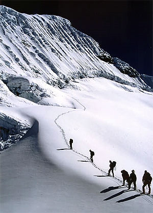
Island Peak, Himalayas, 6.189m

Since I decided to do this trip I have always felt incredibly nervous about it. So why do it, you may ask? Well there are several reasons why it is happening, and so let me explain.

Firstly I needed since doing Kilimanjaro to push myself higher and harder, and this has both of those elements.

Secondly I have a love affair with Everest, the whole notion of it, and have become a junkie to books, films, websites about it. I claim to have so far scratched only the surface of it, but I had to go there and see it, it has become a pilgrimage in that respect.

Thirdly, it is because of so many people saying that Everest Base Camp is so, well, uninteresting, that I had to do something else to combine it with. I am told that EBC is dirty, that you can’t see Everest itself from there (or not the summit anyway), that it is ugly and featureless. I care about none of those things of course – for me just being there will be the greatest thrill imaginable.

Fourth, it is about reaching a peak. If you have followed my blog previously you will know that whilst I don’t spend a lot of time on mountains, my greatest emotions seem to come out when attaining a summit. It can be a small ridge in the Lake District, or a massive climb with fixed ropes and ice axes like this one, but the attainment and the achievement is always the same, and something that I can scarcely put into words.

This trip actually is the product of a number of things, most particularly a conversation between me and a friend Paul, of “Darina and Paul” fame from Kilimanjaro (see previous blogs again, or let me know, I can send you links if you ask me nicely :)). So after we had been skiing earlier this year, Paul said that he’d like to go to Annapurna. I did too, but I felt that I couldn’t go to the Himalayas without at least seeing Everest, it just wouldn’t have been right for me. Paul then said that he wouldn’t like to just go to Base Camp without climbing a mountain, and I agreed, it would be frustrating. So we agreed to not do the trip basically, although then I decided that I just had to go and do it. Paul is now doing the New York Marathon, and will be off there soon (whilst I am away in fact) to do just that. So to Paul (and Darina, and Jason, and Ryan, and everyone else who is doing it) – I wish you the very very best of luck.

This trip for me is harder by a long chalk than anything that I have ever done. I will spend over a week at altitudes over 5.5km up in the air. I will be climbing an ice ridge which totally freaks me out.

I am so excited about it that I don’t know if I will sleep tonight at all.

There will be no more blog posts from me until I return from my trip, as I do not have the means to get them up here live as far as I know. I will do a daily diary however, and will describe to the fullest the things I experience, and this will be posted when I am back.

I am going on the same path as that followed by all of the great Everest expeditions themselves, from Edmund Hillary and Tensing Norgay, to Reinhold Messner and Ed Viesturs, and all of the mountaineering greats. I will move from the Dudh Kosi Valley to the Khumbu, passing through evocatively named places liked Namche Bazaar, until I reach the mighty Kumbu Icefall, which is the glacier coming down from Everest herself.

When I (hopefully) reach my destination of Island Peak, I will from the summit at around 20,400 feet be amidst (and be staring at) three of the highest five peaks on earth.

The words ‘bring it on’ seem sorely and hopelessly inadequate. I hope I am up to it……may I say wish me luck?

Kit List for Everest Base Camp

So I have just four days to go, and four sleeps to go, until I embark on the greatest adventure of my life. I thought that Kilimanjaro was (and it was) massive, but this is simply bigger by miles. Kilimanjaro was a 7 day trek, and it took me to 19,340 feet. It was the best adventure I have ever had, and may stay that way, as I have no idea how this one will yet turn out. This trip is 22 days, takes me into the heart of the world’s highest mountain range, involves ice climbing with technical equipment, and takes me up to 20,305 feet. And to boot I get to stand in front of Mount Everest, the mother of them all.

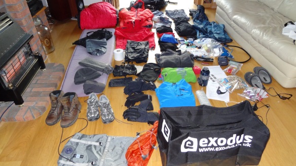
If I told you that I was just a little bit excited at the moment, then that would be the ‘mother’ of all understatements. I have been like a cat on a hot tin roof all day today. I cannot keep still, my heart is racing, I have probably burned about 5,000 calories in nervous energy – who needs the gym! I started to lay out my kit too, and buying the last few items that I will need. More on those later, but for now I thought I’d put down here the kit that I am taking. If anyone out there wishes to comment on the appropriateness or otherwise of what I have here, then I’d be very grateful. I still have no idea how I am actually going to get it all in and under the weight limit, but for now I am still assembling, so I will get to think about what I take away later.

So here’s what I have so far:

Everest base camp kit

So we have here:

Clothing

3 base layer T shirts

2 sets of thermal underwear

1 pair lightweight trekking trousers

1 pair fleece lined trekking trousers

4 pairs of socks

2 marino wool tops

2 light fleeces

Outerlayers

1 Goretex rainjacket

1 Goretex overtrousers

1 (very toasty) Rab Neutrino Plus down jacket

1 Rab Generator Alpine jacket

1 midweight Polartec Fleece

1 woolly hat, 1 cap, 1 scarf, and one buff

1 balaclava (looks like a gimp mask, hope I don’t get to have to wear it :O)

3 pairs of gloves (inner fleece, outer shell, and goretex padded)

Walking boots (my trusty Meindl Burma Pros from Kilimanjaro, best bit of kit I have ever bought)

Trainers/approach shoes for camp

Electronics

Powermonkey charger

Suunto altimeter watch

Sony HX9V camera (bought today, hope it’s good!), plus extra batteries

iPad (I hope to keep my blog written up whilst away, charging it isn’t going to be easy though)

Spare mobile phone (Nokia C3 – hoping to be able to charge my iPhone en route so this is a back up really)

Headtorch plus spare batteries.

Other gear

Rab Summit 700 sleeping bag

Thermarest

Glacier glasses plus spare sunglasses

Camelback with insulated hose

Drinking bottles x 2

Gaiters

Rucksack (Deuter Guide 35+)

Toiletries etc

Toilet roll (may need to take 10 of these :))

Sunscreen (factor 30+)

Chapstick

Paracetamol

Immodium

Compeed

Various sticking plasters

70 pairs of contact lenses 🙂

Anti bacterial gel

Baby Wipes (my only means of washing as far as I am aware)

Travel towel

NO Diamox (I understand that I can buy it in Kathmandu, and buy it I will)

Other bits and bobs

Book (Bear Grylls’ “Facing Up”)

About 20 Clif Bars, about 10 Clif Shot Blocks, and 10 Zipvit Energy Gels (these may all be casualties, they weigh collectively 2.5kg :))

Water purification tablets (x 100 or so)

Compression sacks and bin liners

Travel Insurance documents

And that’s about it. Sounds like a lot, but this is only the stuff for Everest Base Camp. I also have to have harness, ice axe, helmet, figure of eight, Slings, jumar, plastic boots, hand warmers etc etc. for Island Peak. The above also includes no ‘normal’ clothes – no underwear, T shirts, jumpers, or anything else for that matter. There won’t be room of course, as the above list I have to get down to just 12kg! That is going to be a nightmare, but it will be apparently weighed at the hotel in Kathmandhu, and I have to do it somehow.

So as I said earlier – any and all comments welcome. The bag (that would be the small Exodus one in the foreground) will be packed and unpacked a few times in the next few days, and the air will be very blue indeed inside my house……I shall let you know how it is all going tomorrow.